Jurisdictions

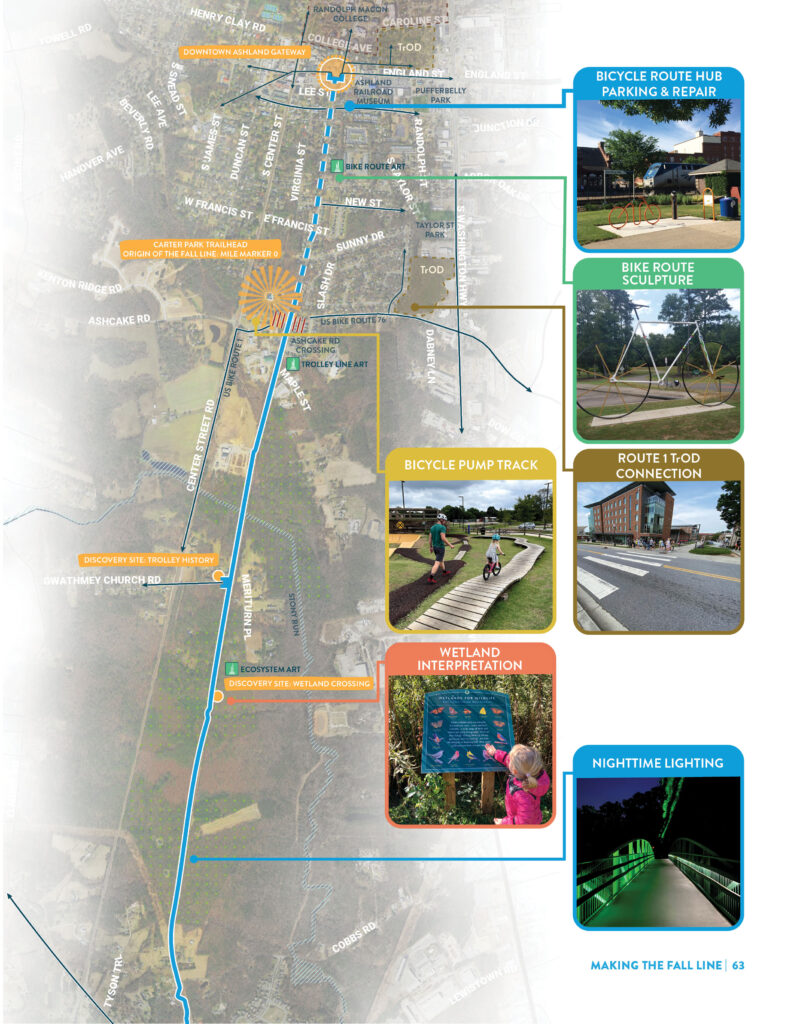
  • Trolley Line – Ashland/Hanover County

    Overview

    The Trolley Line character area starts at the northern gateway of the Fall Line at Carter Park in the Town of Ashland. The trail follows the old trolley line that last carried passengers between Richmond and Ashland more than 80 years ago.Downtown Ashland and Randolph Macon College are less than a mile from the trailhead. For those just beginning their journey, the Trolley Line section covers the first two miles through peaceful woodlands to the intersection with Cobbs Road in Hanover County.

    Vision Elements

    The Fall Line through this context area incorporates elements of the Main Street Trail north into Ashland and the Scenic Route typology south through the existing Trolley Line corridor. Key elements of these typologies for this section include:

    • On-street bicycle and pedestrian connections into downtown Ashland
    • Historical markers
    • Boardwalks and interpretive signage through environmentally sensitive areas
  • Power Line – Hanover/Henrico Counties

    Overview

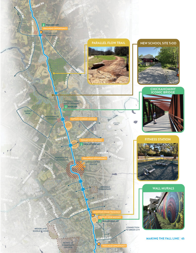
    Traveling south from Cobbs Road, the Fall Line trail begins a nearly six mile segment along a wide power line easement. This character area is dominated by forests and farmland in the northern approach to the Chickahominy River crossing just north of Woodman Road. Continuing south, the trail passes through the suburban neighborhoods of Glen Allen, crosses I-295 and connects to commercial, institutional, and recreational destinations on either side of Parham Road.

    Vision Elements

    The Fall Line becomes both a Scenic Route and as a Neighborhood Trail through the Power Line character area. Key elements of these typologies for this section include:

    • On-street connections to Virginia Center Commons and Parham Road shopping centers
    • Interstate overlay at I-295
    • Emphasis on elevating the natural experience through wooded areas north of the Chickahominy River
    • Solar light fixtures with automatic detection and adjustable timing
  • Boulevard of Brooks – Henrico County/ Richmond City

    Overview

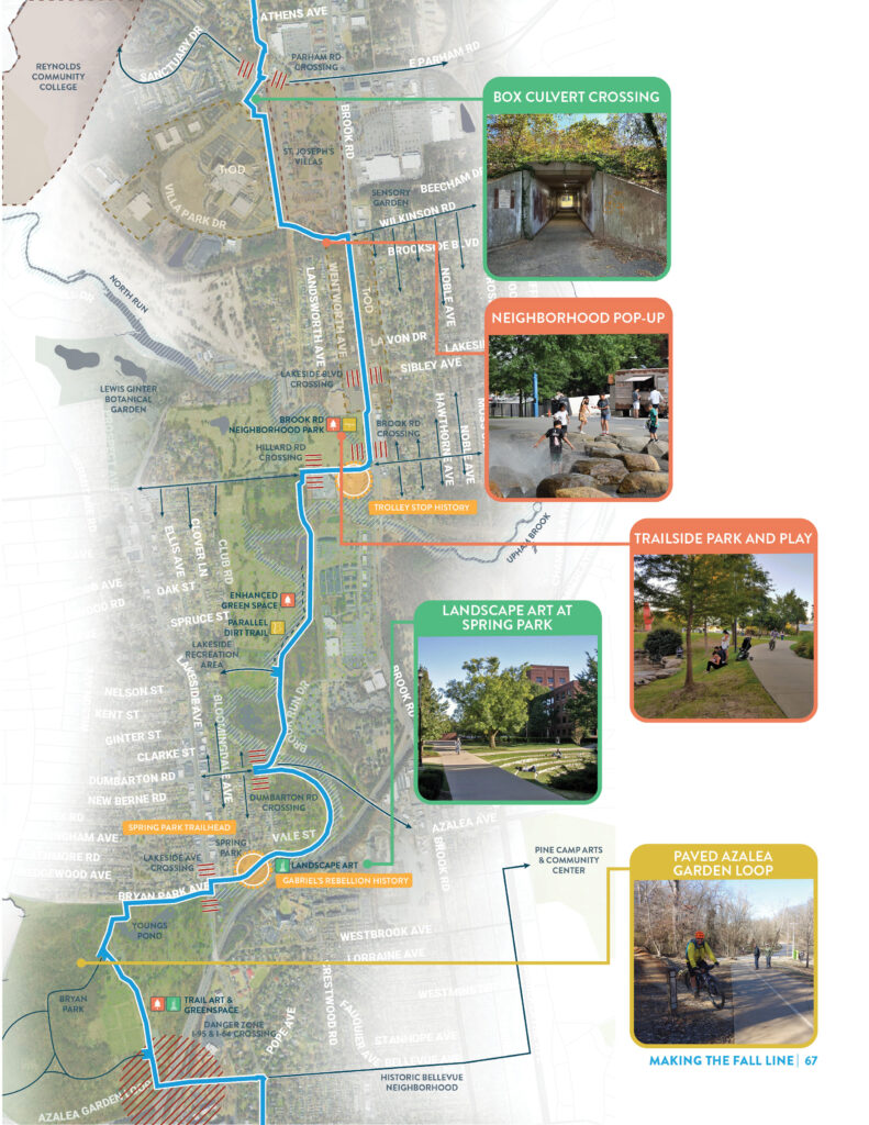
    This section of trail runs parallel to, or directly along, Brook Road in Henrico County and provides direct access to numerous popular park and recreation facilities, including the much loved Lewis Ginter Botanical Garden and Belmont Park. This 4-mile stretch is also defined by Upham Brook which flows into Bryan Park in the City of Richmond.

    Vision Elements

    The Neighborhood Trail typology is most applicable for most portions of this area, however the trail also becomes a Scenic Route as it winds along Upham Brook. Key elements of these typologies in this area include:

    • Opportunities to catalyze economic development along Villa Park Drive
    • Neighborhood trail access throughout Lakeside
    • Signature trail entrance at Bryan Park
    • Solar light fixtures with automatic detection and adjustable timing
  • Richmond Northside

    Overview

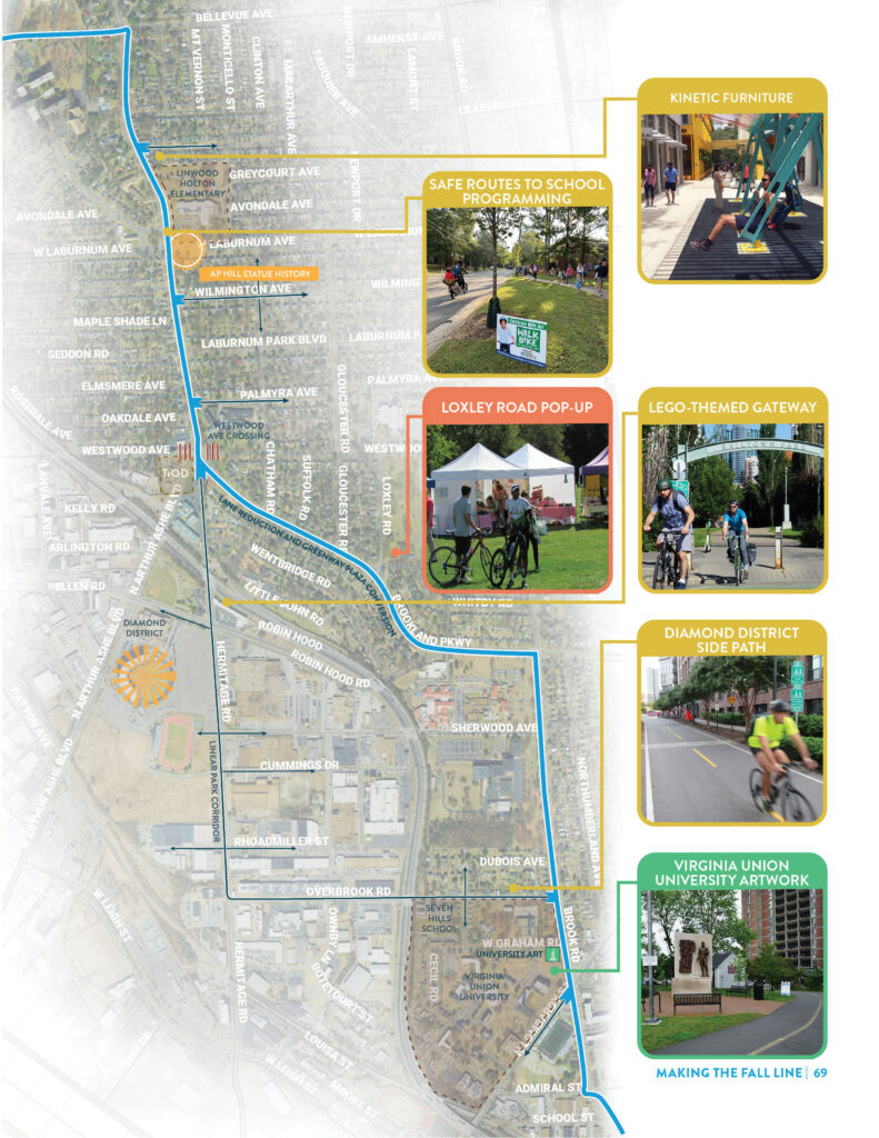
    South of Bellevue Avenue and the I-95 crossing, the character shifts to denser, historic neighborhoods within the Richmond city limits. Here the Fall Line enhances existing on-street bicycle connections to bring trail users to major destinations including the Diamond District, Virginia Union University, Virginia Commonwealth University Athletic Village, and Linwood Holton Elementary School. The downtown Richmond skyline beckons through the trees as you pass through a blended landscape of new and old, work, play, and home.

    Vision Elements

    The Fall Line serves as a Neighborhood Trail through this entire character area. Key elements of the typology here include:

    • Connections to Linwood Holton Elementary and surrounding neighborhoods
    • Upgraded underpass and transition through the Diamond District
    • Adjacency and access to Virginia Union University
  • Richmond City

    Overview

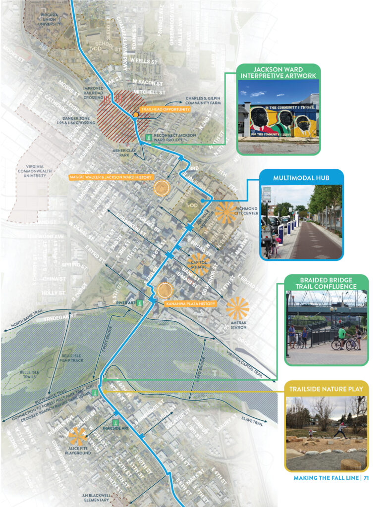
    Downtown Richmond is the heart of the Fall Line and where the geologic fall line itself appears in the waters of the James River. Layers of history, from prehistoric times to the civil war, create a tapestry of told and untold stories. Activity along the corridor bursts open with access to universities, dining, and corporate headquarters just minutes away from world-class mountain biking trails, whitewater kayaking and peaceful river overlooks. Here, the Fall Line trail becomes a promenade for those commuting in and out of the city center, while seamlessly fading into Richmond’s braided network of trails across the river.

    Vision Elements

    While the trail through this area has an abundance of scenic moments, it functions as a Main Street Trail throughout. Key elements of this typology include:

    • Numerous connections to nearby trail networks through downtown and along the James River
    • Trail spurs and routes to historical sites
    • Multimodal hub along the trail adjacent to the Richmond Convention Center
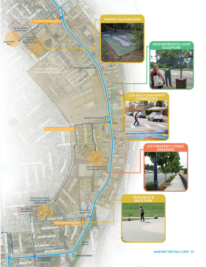
  • Commerce Road

    Overview

    South of the James River, the Fall Line begins a 2.5-mile arc along Commerce Road and Bellemeade Road. The corridor is dominated by industrial and manufacturing sites but redevelopment seems inevitable as Manchester expands southwards. Here, the Fall Line etches in an alternative to the area’s auto-dominated past and brings renewed connectivity to neighborhoods cut off by I-95, rail lines, and the river. A place designed for cars becomes an extension of the trails along the James River. Spaces for shade and rest peel back the concrete landscape to reveal a human-scaled transportation corridor with the best view of Richmond’s downtown.

    Vision Elements

    In this context area the Fall Line Trail primarily serves as a Point to Point Connector. Key elements include:

    • Access to Bellemeade Community Center
    • Safe trail crossings at high-stress intersections
    • Connections to Goode’s Creek, the future Broad Rock Creek Park, and the James River Branch Line
    • Prioritized shade and seating at transit stops
    • Long-desired river connection for Oak Grove Community
    • Alternate route through neighborhood streets for lower stress, more nuanced experience
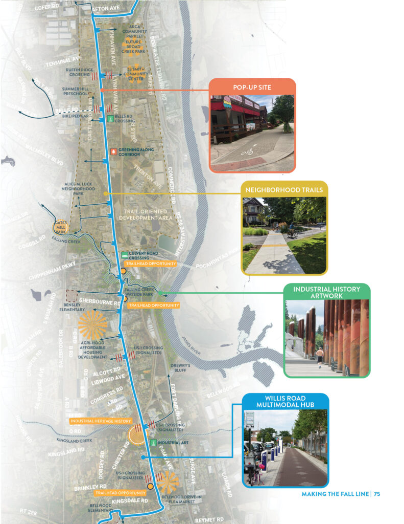
  • Industrial Heritage

    Overview

    Stretching from Bellemeade Road to Galena Avenue in Chesterfield County, theb Fall Line travels along US Route 1 for nearly 7 miles. While today the landscape is dominated by asphalt and fast-moving cars, the future of this corridor lies in trail- oriented revitalization, transportation access and safety for local communities. The Fall Line through Route 1 brings together stories of industrial strength and roadside diners, with new comforts and amenities to help any Fall Line user continue on their journey. These local flavors will create a standout destination area unlike anywhere along the rest of the trail.

    Vision Elements

    The Fall Line serves as a Neighborhood Trail through most of this character area with portions acting as Point to Point Connector. Key elements of this typology here include:

    • Numerous trailheads and neighborhood access points
    • Signalized crossings along US-1
    • Trailhead with parking near the Bellwood Drive-In Flea Market
    • Pop-Up site opportunities near Summer Hill Preschool, the TB Smith Community Center, and the Future Broad Creek Park
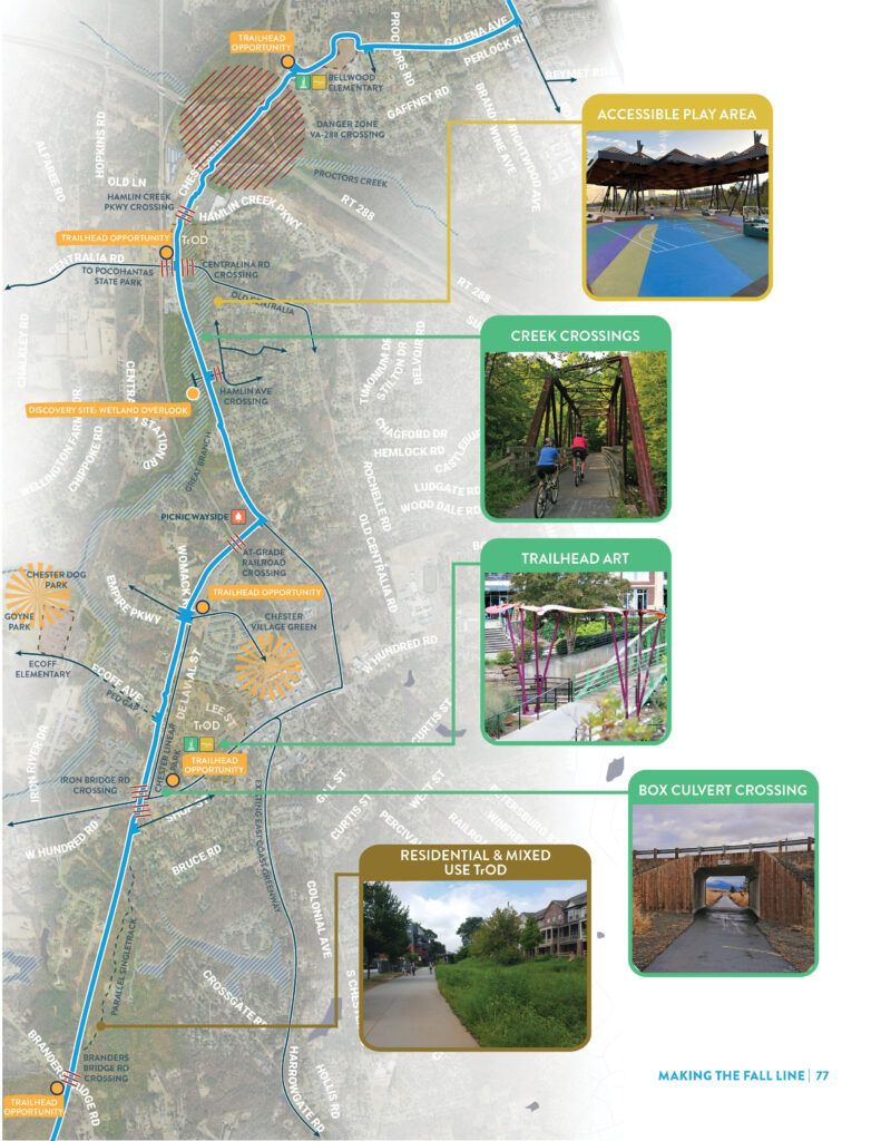
  • Cross Chester Connector – Chester

    Overview

    Moving away from Route 1, the Fall Line takes on a much more residential character through Chester. The trail passes under VA Route 288, and makes its way around the western border of Chester Village before continuing south to Branders Bridge Road. Key highlights in this area include access to the Gonye Park and local shops in the Village of Chester.

    Vision Elements

    The Fall Line serves as a Neighborhood Trail through this entire character area. Key elements of this typology here include:

    • Alternate routes and spurs connecting to the Chester Village Green
    • Nature-based and accessible play areas serving adjacent communities
    • Transit-oriented development opportunities north of Branders Bridge Rd
    • Signature Trailhead at Chester Linear Park and Route 10
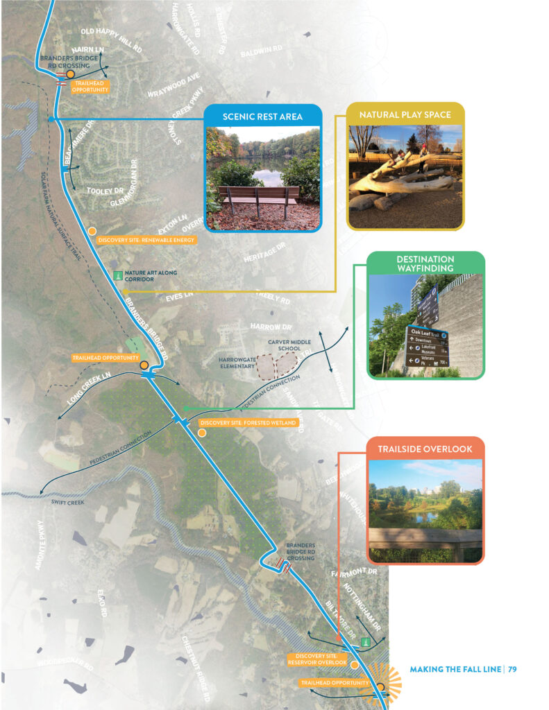
  • Reservoir Ramble – Chesterfield County

    Overview

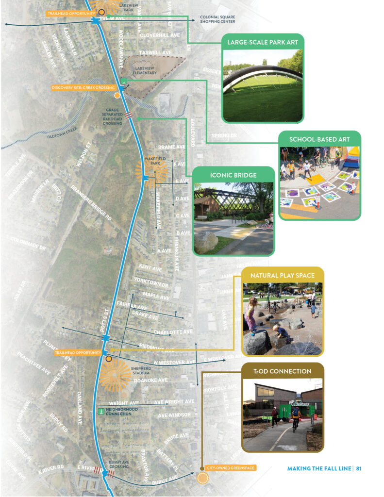
    The trail between Chester and Colonial Heights is one of the most pristine and naturally rich sections of the entire Fall Line. The trail parallels Branders Bridge Road, with buffered wetlands and mature forests on both sides. The most notable feature in this section is the stunning lake overlook just west of the Stony Glenn Neighborhood. Here, regardless of their ultimate destination, trail users will want to pause and take in the view. Opportunities for ecological wonder and discovery continue as the trail moves south culminating with the iconic land bridge over Swift Creek at Lakeview Park.

    Vision Elements

    The Fall Line serves as a Scenic Route through this entire character area. Key elements of this typology here include:

    • Natural area exploration in forested wetlands north of Swift Creek
    • Overlook and scenic view opportunities at Lakeview Park and other water areas
  • Colonial Heights

    Overview

    The Fall Line continues to travel through wetlands and forests as it passes Lakeview Elementary School and curves into Colonial Heights. This section of trail offers opportunities for multiple iconic crossings – including over Old Town Creek, the railroad, Branders Bridge Road, and E. River Road. Key trailheads will create easy connections between the Fall Line and Boulevard to the east and west for trail users commuting to downtown Colonial Heights, catching a Chili Peppers game at Shepherd Stadium, visiting Village of Ettrick on a Saturday morning, or starting a journey at the Amtrak station.

    Vision Elements

    The Fall Line serves as a Neighborhood Trail through this entire character area. Key elements of this typology here include:

    • Iconic bridge at the grade separated rail crossing south of Oldtown Creek
    • Trailhead and connections to Shepherd Stadium and adjacent neighborhoods
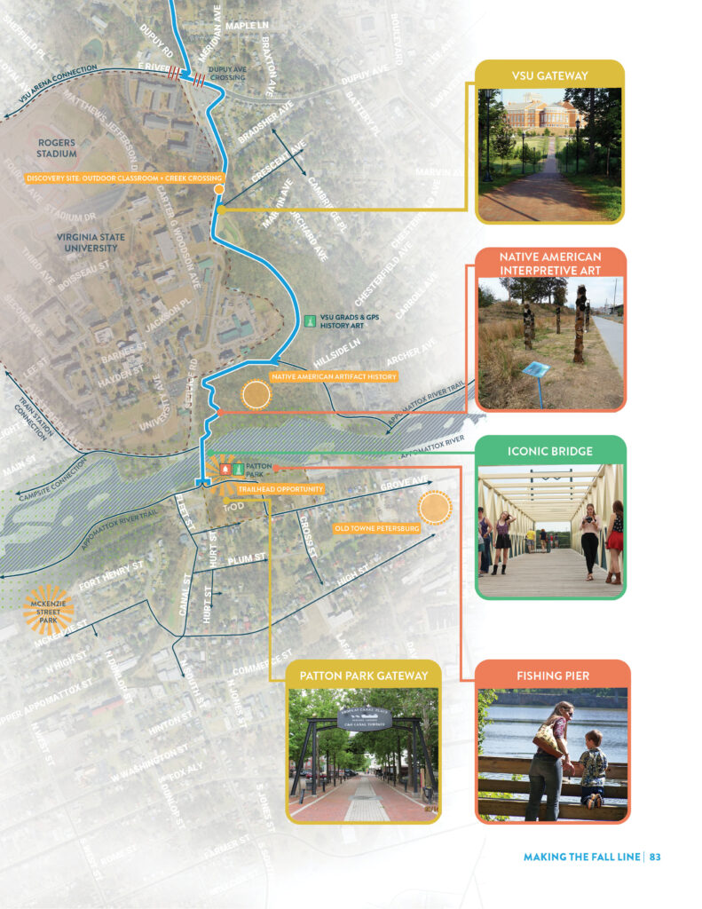
  • Southern Gateway – Petersburg

    Overview

    The southern terminus of the trail marks the end of the journey for some, but for many, crossing the Appomattox River is only the beginning of the next adventure. Downtown Petersburg and the East Coast Greenway to the south, the Appomattox River Trail to the east and west and 43 miles of the Fall Line to the north all point to a journey that continues well beyond the reach of the trail. The Southern Gateway becomes a microcosm of the entire Fall Line experience. Virginia State University (VSU), historic Petersburg, and crossing the Appomattox River all weave together to announce the overflowing culture, history, and natural beauty of the trail ahead.

    Vision Elements

    The Fall Line serves as a Main Street Trail through this entire character area. Key elements of this typology here include:

    • Access points near Virginia State University campus
    • Public art and interpretive exhibits that celebrate Black history at VSU and the history of indigenous peoples
    • Signature gateway and experiential elements at Patton Park, including improved river and fishing access, bicycle repair and parking, play spaces, and upgraded restrooms
    • Connections to Old Towne Petersburg and local landmarks